Ribadesella
View Screen
View Web
bg1

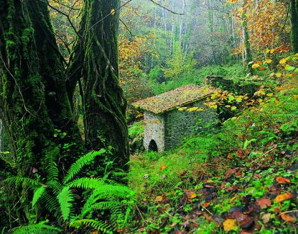
Virgen de guía chapel

Description

Altered in 1892, this 16th century construction is standing at the perfect point for a complete panoramic view over the Sella river’s estuary. The splendid southern façade still remains on its undeniable original Renaissance style. However, if you look at its eastern wall you’ll realise that nowadays the chancel part of the chapel is missing. Probably a landslide made it collapsed in an imprecise moment of its history.

View map

VEGA BEACH AND ENTREPEÑES DEFILE NATURAL MONUMENT

Description

The Entrepeñes defile is an unexpected stony panorama carved alternately by the Acebu stream waters and the activity of marine tides. The magnificent geological formations rise up from the course of the river as capricious quartzite pinnacles, and in some cases they soar 60 m high. So that, the mineral ensemble make of this space an amazing natural sculpture.

Beside the road you’ll find a picnic area, with tables and benches, to peacefully enjoy the beauty of the site.

View map

L’atalaya stony beach

Description

This cosy stony beach is formed by flat loam rocks at the foot of the Jurassic cliffs that involve the old village. Perfect for sunbathing during the summertime, it is really easy to get there from Villar y Valle square. L’Atalaya cove was traditionally frequented by local society before Santa Marina sandy beach, on the western side of the river, became popular. Limpets, winkles and sea urchins have been always considered a local delicatessen, so they were usually gathered here by residents. 

View map

Ardines cuevona (big cave)

Description

Formed by the collapse of several superposed galleries, its colossal main chamber stands there unexpectedly as a colossal 40 m high underground cupola. Open to the exterior on its ceiling, this naturally lightened cavern was used as a recurrent shelter by Prehistoric men. This is why today it is considered an important archaeological site.
Its dimension and acoustic values has made this cave became the site of a Classical Music local festival that is celebrated in Ribadesella every summer.

View map

Samuel Cachero´s path

Description

This 4 km long route starts at Cuerres village, so to get there you will have to drive along AS263 to the eastern limit of Ribadesella’s borough.

View map

The way of Saint Jame´s route

Description

The Way of Saint James route starts in Cuerres, the first village on the eastern part of the district. To get there, you have to drive 6 km from Ribadesella to the east, along AS-263 road.

View map

The mills route

Description

The starting point of this 9 km long route is Cueves del Agua village, where a signposted steep trail leads up to Monte Moru, the summit of your walk, beside Tresmonte village. Past 4 km you’ll get to Tresmonte road where a sign indicates Tresmonte location. From the top of the road a magnificent bird’s-eye view over the whole district is available. Then, continuing to your left to the south, down along the steep road, you will finally get to Tresmonte, the highest village in the municipality.

View map

Santa marina beach

Description

This 1 km long urban beach is considered the best sandy area for visitors in the district. It spreads from the left side of the estuary of the Sella River to the Jurassic layers of Somos hill, on its western limit. Santa Marina beach holds the Q Quality Certificate, a national label that guarantees its excellent set of equipment and services: aid post, lifeguard, PA system, watch tower, showers, toilets, disabled people’ service, beach bars and parking.

View map

Pages

Subscribe to Turismo Ribadesella RSS
en